-40%
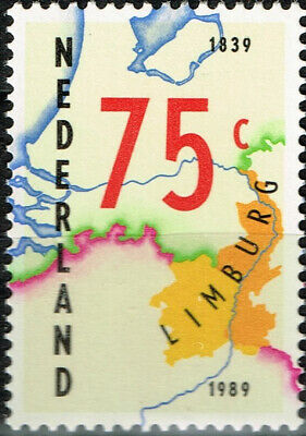
Netherlands Limburg Map stamp 1989 MNH
$ 2.63
- Description
- Size Guide
Description
Good stamp.Limburg
is the southernmost of the 12 provinces of the Netherlands. The province is in the southeastern part of the country, stretched out from the north, where it touches the province of Gelderland. Its northern part has the province of North Brabant to its west. Its long eastern boundary is the international border with the German state of North Rhine-Westphalia. Much of the west border runs along the River Maas, bordering the Flemish province which is also named Limburg. On the south end it borders the Walloon province of Liège. The Vaalserberg is on the extreme south-eastern point, marking the tripoint of the Netherlands, Germany and Belgium. Limburg's major cities are the provincial capital Maastricht (pop. 121,565), as well as Venlo (pop. 101,603) in the Northeast, and Sittard-Geleen (pop. 92,661) and Heerlen (pop. 86,832) in the south. More than half of the population, approximately 650,000 people, live in the south of Limburg, which corresponds to roughly one-third of the province's area proper. In South Limburg, most people live in the urban agglomerations of Maastricht, Parkstad and Sittard-Geleen. Limburg has a highly distinctive character. The social and economic trends that have affected the province in recent decades have generated a process of change and renewal which has enabled Limburg to transform its peripheral location into a highly globalized regional nexus, linking the Netherlands to the Ruhr metro area in Germany and the southern part of the Benelux region. A less appreciated consequence of this international gateway location is rising international crime, often drug-related, especially in the southernmost part of the province.
